Jaipur metro routes are divided into two phases i.e. Phase –I and phase –II respectively.
1). Phase-I (East-West Corridor) GREEN LINE
2). Phase-II (North-South Corridor) ORANGE LINE
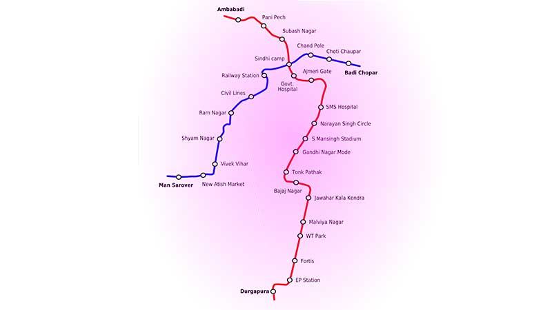
Jaipur Metro Map Route of Phase -I
This Phase starts from Mansarovar and ends at Badi Chaupar. Total length of this phase is 12.067 KM and it consists of 11 Metro Stations (8 Elevated and 3 Underground).
Mansarovar – New Aatish Market – Vivek Vihar – Shyam Nagar – Ram Nagar – Civil Lines – Railway Station – Sindhi Camp – Chand Pole – Choti Chaupar – Badi Chaupar
Jaipur Metro Map Route of Phase -II
This Phase starts from Sitapura Industrial Area and ends at Ambabari. Total length of this phase is 23 KM and it consists of 20 Metro Stations (15 Elevated and 5 Underground).
Sitapura Industrial Area – Pratap Nagar – Haldi Ghati Gate – Sanganer – Laxmi Nagar – Durgapura – Mahaveer Nagar – Gopalpura – Dev Nagar – Tonk Phatak – Gandhi Nagar Mode – Sawai Mansingh Stadium – Narayan Singh Circle – SMS Hospital – Ajmeri Gate – Government Hostel – Sindhi Camp – Subhash Nagar – Pani Pech – Ambabari